226305 materialEducativo

textoFiltroFicha

Spurn

tipo de documento Wikipedia-Artikel

  • Gefällt mir 0
  • Besuche/Aufrufe 33
  • Kommentare 0
  • Speichert in
  • Aktionen

Über diese Ressource...

Spurn
Artículo WikipediaFuente Dbpedia
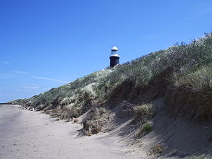
Spurn Point (or Spurn Head as it is also known) is a narrow sand spit on the tip of the coast of the East Riding of Yorkshire, England that reaches into the North Sea and forms the north bank of the mouth of the Humber estuary. It is over 3 miles (4.8 km) long, almost half the width of the estuary at that point, and as little as 50 yards (46 m) wide in places. The southernmost tip is known as Spurn Head or Spurn Point and is the home to an RNLI lifeboat station and disused lighthouse. It forms part of the civil parish of Easington.Spurn Head covers 280 acres (113 ha) above high water and 450 acres (181 ha) of foreshore. It has been owned since 1960 by the Yorkshire Wildlife Trust and is a designated National Nature Reserve, Heritage Coast and is part of the Humber Flats, Marshes and Coast Special Protection Area.
Cabo Spurn
Población total 50

Konzeptionelle Karte: Cabo Spurn

Exklusive Inhalte für Mitglieder von

D/i/d/a/c/t/a/l/i/a
Anmelden

Mira un ejemplo de lo que te pierdes

Kategorien:

Fecha publicación: 7.9.2014

Kommentieren

0

Möchtest du einen Kommentar abgeben? Registriere dich oder inicia sesión

Mach mit bei Didactalia

Browse among 226305 resources and 560618 people

Regístrate >

O conéctate a través de:

Si ya eres usuario, Inicia sesión

Möchten Sie auf weitere Bildungsinhalte zugreifen?

Einloggen Tritt einer Klasse bei
x

Add to Didactalia Arrastra el botón a la barra de marcadores del navegador y comparte tus contenidos preferidos. Más info...

Spielhilfe
Juegos de anatomía
Selecciona nivel educativo