226297 materialEducativo

textoFiltroFicha

Spurn

tipo de documento Artigo da Wikipedia

  • Eu curto 0
  • Visitas 33
  • Comentarios 0
  • Guardar en
  • Ações

Sobre este recurso...

Spurn
Artículo WikipediaFuente Dbpedia
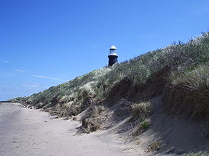
Spurn Point (or Spurn Head as it is also known) is a narrow sand spit on the tip of the coast of the East Riding of Yorkshire, England that reaches into the North Sea and forms the north bank of the mouth of the Humber estuary. It is over 3 miles (4.8 km) long, almost half the width of the estuary at that point, and as little as 50 yards (46 m) wide in places. The southernmost tip is known as Spurn Head or Spurn Point and is the home to an RNLI lifeboat station and disused lighthouse. It forms part of the civil parish of Easington.Spurn Head covers 280 acres (113 ha) above high water and 450 acres (181 ha) of foreshore. It has been owned since 1960 by the Yorkshire Wildlife Trust and is a designated National Nature Reserve, Heritage Coast and is part of the Humber Flats, Marshes and Coast Special Protection Area.
Cabo Spurn
Población total 50

Mapa conceitual: Cabo Spurn

Conteúdo exclusivo para membros de

D/i/d/a/c/t/a/l/i/a
Iniciar sessão

Mira un ejemplo de lo que te pierdes

Categorias:

Fecha publicación: 7.9.2014

Comentar

0

Deseja fazer um comentário? Registrar o Iniciar sessão

Junte-se à Didactalia

Navegue entre 226297 recursos e 560154 pessoas

Regístrate >

O conéctate a través de:

Si ya eres usuario, Inicia sesión

Você quer acessar mais conteúdo educacional?

Iniciar sessao Participar de uma aula
x

Adicionar ao Didactalia Arrastra el botón a la barra de marcadores del navegador y comparte tus contenidos preferidos. Más info...

Ajuda do jogo
Juegos de anatomía
Selecciona nivel educativo