226294 materialEducativo

textoFiltroFicha
  • Mi piace 0
  • Visite 3
  • Commenti 0
  • Salva su
  • Azioni

Info su questa risorsa...

Dearborn River
River
Artículo WikipediaFuente Dbpedia
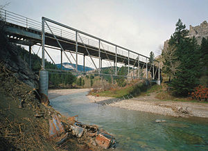
The Dearborn River is a tributary of the Missouri River, approximately 70 mi (113 km) long, in western Montana in the United States. It rises in the Lewis and Clark National Forest, near Scapegoat Mountain in the Lewis and Clark Range of the Rocky Mountains at the continental divide, in western Lewis and Clark County. It flows generally southeast through secluded canyons, and joins the Missouri near Craig.It is crossed by the Dearborn River High Bridge, which was constructed in 1897.It is a popular destination for whitewater rafting and fly fishing. Whirling disease has become a significant problem among trout in the river.The Dearborn is a Class I river for stream access for recreational purposes from the highway 431 bridge to its confluence with the Missouri river.
Dearborn River
Longitud 112654.080000
Desembocadura entre elevaciones 1046.073600
Cuenca hidrográfica (km2) 1061895125.237760

Mappa concettuale: Dearborn River

Contenuti esclusivi per i membri di

D/i/d/a/c/t/a/l/i/a
Il login

Mira un ejemplo de lo que te pierdes

Categorie:

Fecha publicación: 30.5.2015

Commenta

0

Vuoi lasciare un commento? Iscriviti o inizia sessione

Unisciti a Didactalia

Browse among 226294 resources and 559918 people

Regístrate >

O conéctate a través de:

Si ya eres usuario, Inicia sesión

Vuoi accedere a più contenuti educativi?

Inizia la sessione Unisciti a una lezione
x

Aggiungere a Didactalia Arrastra el botón a la barra de marcadores del navegador y comparte tus contenidos preferidos. Más info...

Gioco Aiuto
Juegos de anatomía
Selecciona nivel educativo