What can I do?

226310 materialEducativo

textoFiltroFicha
  • I like 0
  • Visits 3
  • Comments 0
  • Save to
  • Actions

About this resource...

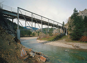
Dearborn River
River
Wikipedia articleDbpedia source
The Dearborn River is a tributary of the Missouri River, approximately 70 mi (113 km) long, in western Montana in the United States. It rises in the Lewis and Clark National Forest, near Scapegoat Mountain in the Lewis and Clark Range of the Rocky Mountains at the continental divide, in western Lewis and Clark County. It flows generally southeast through secluded canyons, and joins the Missouri near Craig.It is crossed by the Dearborn River High Bridge, which was constructed in 1897.It is a popular destination for whitewater rafting and fly fishing. Whirling disease has become a significant problem among trout in the river.The Dearborn is a Class I river for stream access for recreational purposes from the highway 431 bridge to its confluence with the Missouri river.
Dearborn River
Length (km) 112654.080000
Mouth elevation (µ) 1046.073600
Watershed (km2) 1061895125.237760

Conceptual map: Dearborn River

Exclusive content for members of

D/i/d/a/c/t/a/l/i/a
Sign in

Mira un ejemplo de lo que te pierdes

Categories:

Fecha publicación: 30.5.2015

Comment

0

Do you want to comment? Sign up or Sign in

Join Didactalia

Browse among 226310 resources and 561434 people

Regístrate >

O conéctate a través de:

Si ya eres usuario, Inicia sesión

Do you want to access more educational content?

Sign in Join a class
x

Add to Didactalia Arrastra el botón a la barra de marcadores del navegador y comparte tus contenidos preferidos. Más info...

Game help
Juegos de anatomía
Selecciona nivel educativo