224288 materialEducativo

textoFiltroFicha
  • Gustatzen zait 0
  • Bisitak 32
  • Oharrak 0
  • Hemen gorde:
  • Ekintzak

Baliabide honi buruz...

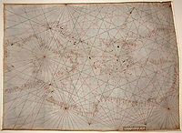
Portolan chart
Definición
Artículo WikipediaFuente Dbpedia
Portolan charts are navigational maps based on compass directions and estimated distances observed by the pilots at sea. They were first made in the 13th century in Italy, and later in Spain and Portugal. With the advent of the Age of Discovery, they were considered State secrets in Portugal and Spain. They were very valuable in the description of Atlantic and Indian coastlines for newcomer English and Dutch raiding, and later trading, ships. The word portolan comes from the Italian adjective portolano, meaning "related to ports or harbours."
Portulano

Mapa kontzeptuala: Portulano

Kide hauentzat bakarrik:

D/i/d/a/c/t/a/l/i/a
Saioa hasteko

Mira un ejemplo de lo que te pierdes

Kategoriak:

Etiketak:

Fecha publicación: 28.8.2014

Aipatu

0

Aipatu nahi al duzu? Erregistratu o Hasi saioa

Zatoz Didactaliara

Navega entre 224288 recursos y 563190 personas

Regístrate >

O conéctate a través de:

Si ya eres usuario, Inicia sesión

Hezkuntza-eduki gehiago eskuratu nahi dituzu?

Saioa hasi Egin bat eskola batekin
x

Didactalia-ri Gehitzea Arrastra el botón a la barra de marcadores del navegador y comparte tus contenidos preferidos. Más info...

Jokoaren laguntza
Juegos de anatomía
Selecciona nivel educativo