226358 materialEducativo

textoFiltroFicha
  • Gefällt mir 0
  • Besuche/Aufrufe 5
  • Kommentare 0
  • Speichert in
  • Aktionen

Über diese Ressource...

Lurgashall
Settlement
Artículo WikipediaFuente Dbpedia
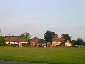
Lurgashall is a village and civil parish in the Chichester district of West Sussex, England. It is 6.5 km (4 ml) north west of Petworth and just inside the new South Downs National Park. The church of St Laurence, The Noah's Ark pub, the old school and several old houses are built around a picturesque village green which contains the village cricket pitch. In the 2001 census the parish covered 21 km² and had 220 households with a total population of 581. 271 residents were economically active.
Lurgashall
Distancia a Londres 64373.760000
Población total 581

Konzeptionelle Karte: Lurgashall

Exklusive Inhalte für Mitglieder von

D/i/d/a/c/t/a/l/i/a
Anmelden

Mira un ejemplo de lo que te pierdes

Kategorien:

Fecha publicación: 27.5.2015

Kommentieren

0

Möchtest du einen Kommentar abgeben? Registriere dich oder inicia sesión

Mach mit bei Didactalia

Browse among 226358 resources and 565576 people

Regístrate >

O conéctate a través de:

Si ya eres usuario, Inicia sesión

Möchten Sie auf weitere Bildungsinhalte zugreifen?

Einloggen Tritt einer Klasse bei
x

Add to Didactalia Arrastra el botón a la barra de marcadores del navegador y comparte tus contenidos preferidos. Más info...

Spielhilfe
Juegos de anatomía
Selecciona nivel educativo