
Cargando...
Cosa posso fare?
226323 materialEducativo
textoFiltroFichaInfo su questa risorsa...
Mapa para imprimir del Himalaya
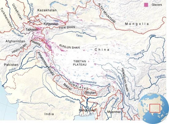
Mapa de relieve con las llamadas “Torres de agua de Asia”, ubicadas en la cordillera de Himalaya. El Himalaya - Hindu Kush , Kunlun Shan , Pamir y Tien Shan son unas cadenas montañosas que funcionan como torres de agua , suministrando agua a gran parte de Asia . Las montañas suponen el hogar de unas 170 millones de personas y los ríos que drenan estas montañas influyen en las vidas de alrededor de un 40 por ciento de la población mundial. Los ríos proporcionan agua en el hogar, alimentación, energía y empleo y son el corazón de las tradiciones culturales.
Es un contenido publicado en www.grida.no
Geographical Information“The Himalayas–Hindu Kush, Kunlun Shan, Pamir and Tien Shan mountain ranges function as water towers, providing water to people through much of Asia. The glacier-fed rivers originating from the Himalaya mountain ranges surrounding the Tibetan Plateau comprise the largest river run-off from any single location in the world. While the mountains are homes to some 170 million people, the rivers that drain these mountains influence the lives of about 40 per cent of the world’s population. The rivers provide household water, food, fisheries, power, jobs and are at the heart of cultural traditions. The rivers shape the landscape and ecosystems and are important in terms of biodiversity. The water towers of Asia While mountains traditionally have been considered the major water sources of the region, there is great diversity in the hydrological significance of mountains and glaciers for downstream water supply, particularly between the dry north-western region and the monsoon-influenced south-eastern regions. In spite of the vast water supply, seasonal water scarcity is a major issue.”
This is a content published at www.grida.no
Asia
Idioma English
Contenuti esclusivi per i membri di

Mira un ejemplo de lo que te pierdes
Autores:
Categorie:
Tags:
Condivisa con:
Vuoi lasciare un commento? Iscriviti o inizia sessione
Si ya eres usuario, Inicia sesión
Aggiungere a Didactalia Arrastra el botón a la barra de marcadores del navegador y comparte tus contenidos preferidos. Más info...


Commenta
0