226353 materialEducativo

textoFiltroFicha
  • Mi piace 0
  • Visite 44
  • Commenti 0
  • Salva su
  • Azioni

Info su questa risorsa...

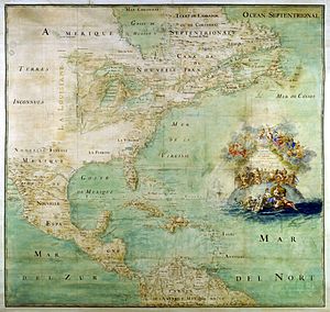
Cartography of the United States
Definición
Artículo WikipediaFuente Dbpedia
Maps of the New World had been produced since the 16th century. The history of cartography of the United States begins in the 18th century, after the declared independence of the Thirteen original colonies on July 4, 1776, during the American Revolutionary War (1775-1783). Later, Samuel Augustus Mitchell published a map of the US in 1867. The National Program for Topographic Mapping was initiated in 1884 by the United States Geological Survey.
Cartography of the United States

Mappa concettuale: Cartography of the United States

Contenuti esclusivi per i membri di

D/i/d/a/c/t/a/l/i/a
Il login

Mira un ejemplo de lo que te pierdes

Categorie:

Fecha publicación: 5.11.2014

Commenta

0

Vuoi lasciare un commento? Iscriviti o inizia sessione

Unisciti a Didactalia

Browse among 226353 resources and 565476 people

Regístrate >

O conéctate a través de:

Si ya eres usuario, Inicia sesión

Vuoi accedere a più contenuti educativi?

Inizia la sessione Unisciti a una lezione
x

Aggiungere a Didactalia Arrastra el botón a la barra de marcadores del navegador y comparte tus contenidos preferidos. Más info...

Gioco Aiuto
Juegos de anatomía
Selecciona nivel educativo