226349 materialEducativo

textoFiltroFicha
  • Gústame 0
  • Visitas 55
  • Comentarios 0
  • Gardar en
  • Accións

Sobre este recurso...

Building
Artículo WikipediaFuente Dbpedia
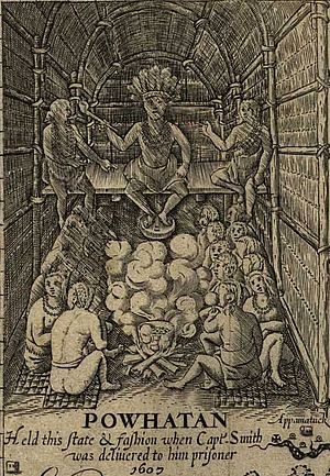
Werowocomoco was a village that served as the political center of the Powhatan Paramount Chiefdom, a grouping of about 30 Virginia Indian tribes speaking an Algonquian language. They lived in the coastal plain area they called Tsenacommacah, in what is now the Commonwealth of Virginia, USA. "Werowocomoco" was documented by English settlers in 1608 as located near the north bank of the York River in what is now Gloucester County — separated by that river and the narrow Virginia Peninsula from Jamestown. Powhatan's Chimney, a site of historical ruins associated with a house said to be built for Powhatan, was traditionally thought to have been the site of the center.In 1977, an archaeologist found ground-surface artifacts at a site further west on the York River on Purtan Bay, about 7 miles (11 km) west of Gloucester. He determined they indicated a late Woodland/early European contact-era settlement. In 2002 current landowners permitted an archaeological survey of their property. It revealed extensive artifacts on what may have been a 50-acre (200,000 m2) settlement, with habitation from 1200 into the 1600s. Archaeologists and anthropologists believe this is the site of Werowocomoco.Since 2003, a team of archaeologists and other researchers have been working there. They and the landowners initiated consultation with the Virginia Council on Indians to plan and execute excavations on the site. Representatives of local Virginia Indian tribes, who are among the descendants of the Powhatan Confederacy, continue to advise and are part of the team. Excavations at the site since 2003 have revealed evidence of a large village, including two 200-foot (61 m)-long, curved, earthwork ditches built 1,000 feet (300 m) from the river bank about 1400, two hundred years before English settlement. In 2006 the Werowocomoco Archeological Site was listed on the National Register of Historic Places (NRHP). Excavations will continue. Scholars hope to find more evidence about the political nature of the chiefdom.
Werowocomoco
Área 182108.539008
Año de construcción 1607

Mapa conceptual: Werowocomoco

Contido exclusivo para membros de

D/i/d/a/c/t/a/l/i/a
Iniciar sesión

Mira un ejemplo de lo que te pierdes

Categorías:

Fecha publicación: 7.9.2014

Comentar

0

Queres comentar? Rexístrate ou inicia sesión

Úneche a Didactalia

Navega entre 226349 recursos e 565025 persoas

Regístrate >

O conéctate a través de:

Si ya eres usuario, Inicia sesión

Queres acceder a máis contidos educativos?

Iniciar sesión Únete a unha clase
x

Engadir a Didactalia Arrastra el botón a la barra de marcadores del navegador y comparte tus contenidos preferidos. Más info...

Axuda do xogo
Juegos de anatomía
Selecciona nivel educativo