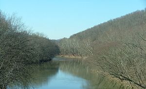
The Big Sandy River is a tributary of the Ohio River, approximately 29 miles (47 km) long, in western West Virginia and northeastern Kentucky in the United States. The river forms part of the boundary between the two states along its entire course. Via the Ohio River, it is part of the Mississippi River watershed.It is formed between Louisa, Kentucky, and Fort Gay, West Virginia, by the confluence of the Tug Fork and Levisa Fork. It flows generally northwardly in a highly meandering course, between Lawrence and Boyd counties in Kentucky and Wayne County in West Virginia. It joins the Ohio between Catlettsburg, Kentucky and Kenova, West Virginia, 8 miles (13 km) west of Huntington, West Virginia, at the common boundary between West Virginia, Kentucky, and Ohio.The river is navigable and carries commercial shipping, primarily coal mined in the immediate region.The name of the river comes from the presence of extensive sand bars. The Native American names for the river included Tatteroa, Chatteroi, and Chatterwha which had similar meaning to the English name.[citation needed] It was known to the Lenape as Sikeacepe,[citation needed] meaning "Salt River", from the presence of salt licks on the river (see: Licking River). The name "Big Sandy" was in use no later than February, 1789. The tombstone of David White, an early settler along the river in Kentucky, marks his passing in 1817 with the note that he lived many years near the Mouth of the Big Sandy. Two well-known fiddle tunes take their name from the Big Sandy River: "Sandy River Belle" and the "Big Sandy River". Loretta Lynn's "Van Lear Rose" and Dwight Yoakam's "Bury Me" also mention the river.
Longitud
46670.976000
Descarga máxima
2531.526085
Descarga mínima
2.293665
Desembocadura entre elevaciones
160.020000
Elevación de la confluencia
809.853600
Elevación de origen
166.116000
793.699200


Comentar
0