226320 materialEducativo

textoFiltroFicha
  • Gústame 0
  • Visitas 7
  • Comentarios 0
  • Gardar en
  • Accións

Sobre este recurso...

Governors Island
PopulatedPlace
Artículo WikipediaFuente Dbpedia
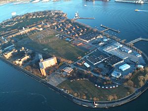
Governors Island is a 172-acre (70 ha) island in Upper New York Bay, approximately one-half mile (1 km) from the southern tip of Manhattan Island and separated from Brooklyn by Buttermilk Channel. It is legally part of the borough of Manhattan in New York City. Physically, the island changed greatly during the early 20th century. Using material excavated from the Lexington Avenue subway, the Army Corps of Engineers supervised the deposit of 4,787,000 cubic yards of fill on the south side of Governors Island, adding 103 acres (42 ha) of flat, treeless land by 1912 and bringing the total acreage of the island to 172.The Native Americans of the Manhattan region referred to the island as "Paggank", meaning 'nut island', doubtless after the island's plentiful hickory, oak, and chestnut trees; the Dutch explorer Adriaen Block called it "Noten Eylant", a translation, and this was borrowed into English as "Nutten Island". The island's current name, made official in 1784, stems from British colonial times when the colonial assembly reserved the island for the exclusive use of New York's royal governors.Defensive works were raised on the island in 1776 by Continental Army troops during the American Revolutionary War, and fired upon British ships before they were taken. From 1783 to 1966, the island was a United States Army post. From 1966 to 1996 the island served as a major United States Coast Guard installation.On January 19, 2001, Fort Jay and Castle Williams, two of the island's three historical fortifications, were proclaimed a National Monument. On January 31, 2003, 150 acres of the island was transferred to the State of New York for $1. The remainder (22 acres or 9 ha) was transferred to the United States Department of the Interior as the Governors Island National Monument, administered by the National Park Service.The 150 acre portion of the island not included in the National Monument is administered by The Trust for Governors Island, an entity of the City of New York and the successor of the joint city/state established redevelopment entity, the Governors Island Preservation and Education Corporation. The transfer included deed restrictions which prohibit permanent housing or casinos on the island.On May 24, 2012, Mayor Michael Bloomberg broke ground on the new park and public spaces designed by the landscape design firm West 8, along with announcing the opening of the rehabilitated Castle Williams.The national historic landmark district, approximately 92 acres (37 ha) of the northern half of the island, is open to the public for several months in the summer and early fall. The circumferential road around the island is also open to the public. The island is accessed by free ferries from Brooklyn and Manhattan.
Governors Island

Mapa conceptual: Governors Island

Contido exclusivo para membros de

D/i/d/a/c/t/a/l/i/a
Iniciar sesión

Mira un ejemplo de lo que te pierdes

Categorías:

Fecha publicación: 29.5.2015

Comentar

0

Queres comentar? Rexístrate ou inicia sesión

Úneche a Didactalia

Navega entre 226320 recursos e 563248 persoas

Regístrate >

O conéctate a través de:

Si ya eres usuario, Inicia sesión

Queres acceder a máis contidos educativos?

Iniciar sesión Únete a unha clase
x

Engadir a Didactalia Arrastra el botón a la barra de marcadores del navegador y comparte tus contenidos preferidos. Más info...

Axuda do xogo
Juegos de anatomía
Selecciona nivel educativo