226302 materialEducativo

textoFiltroFicha
  • Gústame 0
  • Visitas 63
  • Comentarios 0
  • Gardar en
  • Accións

Sobre este recurso...

Thames Estuary
Artículo WikipediaFuente Dbpedia
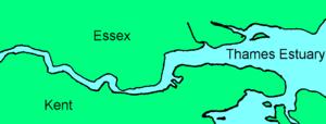
The Thames Estuary is the estuary in which the River Thames meets the waters of the North Sea.It is not easy to define the limits of the estuary. Although physically the head of Sea Reach or the Kent/Essex Strait, south of Canvey Island on the northern (Essex) shore presents a western boundary, the Tideway itself can be considered estuarine; it starts in south-west London at Teddington/Ham. The eastern boundary of the estuary suggested in a Hydrological Survey of 1882-9 is a line drawn from North Foreland, Margate, Kent via the Kentish Knock lighthouse to Harwich in Essex. It is to this line that the typical estuarine sandbanks extend. The estuary downstream of the Tideway has a tidal movement of 4 metres, moving at a speed of 8 miles per hour.[citation needed]The estuary is one of the largest of 170 such inlets on the coast of Great Britain. It constitutes a major shipping route: its thousands of movements each year include large oil tankers, container ships, bulk carriers and roll-on/roll-off (ro-ro) ferries entering the estuary for the Port of London and the Medway Ports of Sheerness, Chatham and Thamesport.The traditional Thames sailing barge worked in this area, designed to be suitable for the shallow waters in the smaller ports. More recently one of the largest wind farms in the UK has been developed in the estuary, located 8.5 km north of Herne Bay, Kent. The farm contains 30 wind turbines generating a total of 82.4MW of electricity. The much larger London Array of up to 1GW capacity is also planned.This area has had several proposed sites for the building of a new airport to supplement, or even to replace Heathrow/Gatwick. In the 1960s Maplin Sands was a contender; in 2002 it was to be at Cliffe, Kent. The new airport would be built on a man-made island in the estuary north of Minster-in-Sheppey There is also some discussion about the need for a Lower Thames Crossing in order to alleviate traffic congestion at Dartford.The Thames Estuary is the focal part of the 21st-century toponym, the "Thames Gateway", designated as one of the principal development areas in Southern England.
Estuario del Támesis

Mapa conceptual: Estuario del Támesis

Contido exclusivo para membros de

D/i/d/a/c/t/a/l/i/a
Iniciar sesión

Mira un ejemplo de lo que te pierdes

Categorías:

Fecha publicación: 6.9.2014

Comentar

0

Queres comentar? Rexístrate ou inicia sesión

Úneche a Didactalia

Navega entre 226302 recursos e 560404 persoas

Regístrate >

O conéctate a través de:

Si ya eres usuario, Inicia sesión

Queres acceder a máis contidos educativos?

Iniciar sesión Únete a unha clase
x

Engadir a Didactalia Arrastra el botón a la barra de marcadores del navegador y comparte tus contenidos preferidos. Más info...

Axuda do xogo
Juegos de anatomía
Selecciona nivel educativo