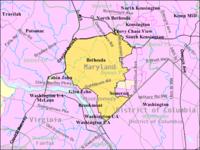
This article is about the city in the U.S. state of Maryland. For pool of water in the Muslim Quarter of Jerusalem, Israel, see Pool of Bethesda. Not to be confused with Bethesda Softworks. Bethesda, Maryland — Census-designated place — Motto: File:Intersection in Bethesda, Maryland. jpg The intersection of Maryland Route 187 (Old Georgetown Road), Maryland Route 355, and Maryland Route 410 (East West Highway), near the Bethesda Metro station entrance, in downtown Bethesda. Boundaries of Bethesda CDP from U.S. Census Bureau Location of Bethesda in Montgomery County, Maryland Coordinates: {{#invoke:Coordinates|coord}}{{#coordinates:38|59|5|N|77|6|47|W|type:city(60858)_region:US-MD |primary |name= }} Country 22x20px United States of America State 22x20px Maryland County 22x20px Montgomery Area • Total 34.2 km (13.2 sq mi) • Land 34.0 km (13.1 sq mi) • Water 0.2 km (0.1 sq mi) Elevation 97 m (318 ft) Population • Total 60,858 • Density 1,623.9/km (4,205.8/sq mi) Time zone Eastern (EST) • Summer EDT ZIP codes 20800-20899 Area code(s) 301 FIPS code 24-07125 GNIS feature ID 0583184 Bethesda is a census-designated place in southern Montgomery County, Maryland, United States, just northwest of Washington, D.C. It takes its name from a local church, the Bethesda Meeting House (1820, rebuilt 1849), which in turn took its name from Jerusalem's Pool of Bethesda. (In Aramaic, בית חסדא beth ḥesda means "House of Mercy" and in Hebrew, בית חסד "beit ḥesed" means "House of Kindness". ) The National Institutes of Health main campus and the Walter Reed National Military Medical Center are in Bethesda, as are a number of corporate and government headquarters. Bethesda is one of the most affluent and highly educated communities in the country, placing first in Forbes list of America's most educated small towns and first on CNNMoney. com's list of top-earning American towns. In April 2009, Forbes ranked Bethesda second on its list of "America's Most Livable Cities. " In October 2009, based on education, income, health, and fitness, Total Beauty ranked Bethesda first on its list of the U.S. 's "Top 10 Hottest-Guy Cities. " As an unincorporated area, Bethesda has no official boundaries. The United States Census Bureau defines a Census-Designated Place named Bethesda whose center is located at 38°59' North, 77°7' West. The United States Geological Survey has defined Bethesda as an area whose center is at {{#invoke:Coordinates|coord}}{{#coordinates:38|58|50|N|77|6|2|W|type:city | |name= }}, slightly different from the Census Bureau's definition. Other definitions are used by the Bethesda Urban Planning District, the United States Postal Service (which defines Bethesda to comprise the zip codes 20810, 20811, 20813, 20814, 20815, 20816, and 20817), and other organizations. According to figures released by the U.S. Census Bureau in 2010, the community had a total population of 60,858. Most of Bethesda's residents are in Maryland Legislative District 16.
Lema
thumb|300px|The intersection of Maryland Route 187 (Old Georgetown Road), Maryland Route 355 (Wisconsin Avenue), and Maryland Route 410 (East West Highway), near the Bethesda Metro station entrance, in downtown Bethesda.
Población total
60858
Huso horario
Eastern Time Zone
Tipo
Census-designated place


Comentar
0