226304 materialEducativo

textoFiltroFicha
  • Gustatzen zait 0
  • Bisitak 0
  • Oharrak 0
  • Hemen gorde:
  • Ekintzak

Baliabide honi buruz...

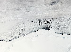
Enderby Land
DbpediaThing
Artículo WikipediaFuente Dbpedia
Enderby Land is a projecting land mass of Antarctica, extending from Shinnan Glacier at about 67°55′S 44°38′E to William Scoresby Bay at 67°24′S 59°34′E. It was discovered in February 1831 by John Biscoe in the whaling brig Tula, and named after the Enderby Brothers of London, owners of the Tula, who encouraged their captains to combine exploration with sealing.Claimed as part of the Australian Antarctic Territory, geographic features of Enderby Land include Amundsen Bay, Casey Bay, Cape Monakov, the Scott Mountains, the Tula Mountains, and the Napier Mountains. The highest peak is Mount McMaster at 2,830 metres (9,280 ft).
Tierra de Enderby

Mapa kontzeptuala: Tierra de Enderby

Kide hauentzat bakarrik:

D/i/d/a/c/t/a/l/i/a
Saioa hasteko

Mira un ejemplo de lo que te pierdes

Kategoriak:

Etiketak:

Fecha publicación: 18.9.2015

Aipatu

0

Aipatu nahi al duzu? Erregistratu o Hasi saioa

Zatoz Didactaliara

Navega entre 226304 recursos y 560507 personas

Regístrate >

O conéctate a través de:

Si ya eres usuario, Inicia sesión

Hezkuntza-eduki gehiago eskuratu nahi dituzu?

Saioa hasi Egin bat eskola batekin
x

Didactalia-ri Gehitzea Arrastra el botón a la barra de marcadores del navegador y comparte tus contenidos preferidos. Más info...

Jokoaren laguntza
Juegos de anatomía
Selecciona nivel educativo