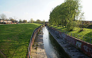
The River Rea (pronounced "ray") is a small river which passes through Birmingham, England. The name of the river derives from a root found in many Indo-European languages and means "to run" or "to flow". It frequently bursts its banks after heavy rain.It rises in Waseley Hills Country Park, with the source well signposted from the carpark there. The river drops about 70 metres (230 ft) in its first mile, but from then on has a very gentle slope. The river's tributaries include Callow Brook, the Bourne (which begins as Merritts Brook before joining Griffins Brook) and Bourne Brook. From Rubery, the river flows into Birmingham near the former Rover works at Longbridge, then flows through a tunnel under the A38. In Northfield, one of the river's few remaining fords is at The Mill Walk, near Hawkesley Mill Lane. After this, the river valley is also used by the railway to Kings Norton.Wychall Reservoir, near the river at Kings Norton, was built in the early 19th century by the Worcester Canal Company after mill owners claimed that water was being taken from the river to fill the canal and reducing the working effectiveness of their mills. Following Kings Norton, the river flows through Stirchley. It is now culverted for much of its course through Birmingham, during which it passes through the Pebble Mill area and Cannon Hill Park. The medieval hamlet of Birmingham was built on a crossing on the Rea in what is now Digbeth. Many of the street names in the area refer to the river or its mills. These include Rea Street, Floodgate Street, River Street and Duddeston Mill Road. There are proposals to include a riverside walk and new bridge over the Rea at Digbeth's Custard Factory media and arts complex (now complete). There are also proposals for the river to be uncovered at the Warwick Bar area of Digbeth.Near Gravelly Hill Interchange, about 14 miles from its source, the Rea becomes a tributary of the River Tame, with its waters eventually reaching the North Sea via the Trent and the Humber Estuary.
Longitud
22530.816000
Origen
Waseley Hills Country Park
Worcestershire


Aipatu
0