What can I do?

226297 materialEducativo

textoFiltroFicha
  • I like 0
  • Visits 6
  • Comments 0
  • Save to
  • Actions

About this resource...

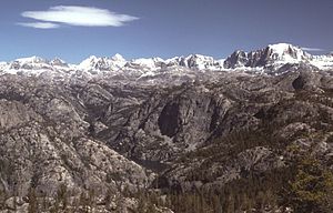
Wind River Range
MountainRange
Wikipedia articleDbpedia source
The Wind River Range (or "Winds" for short), is a mountain range of the Rocky Mountains in western Wyoming in the United States. The range runs roughly NW-SE for approximately 100 miles (161 km). The Continental Divide follows the crest of the range and includes Gannett Peak, which at 13,804 feet (4,207 m), is the highest peak in Wyoming. There are more than 40 other named peaks in excess of 13,000 feet (3,962 m). With the exception of the Grand Teton in the Teton Range, the next 19 highest peaks in Wyoming after Gannett are also in the Winds. Two large National Forests including three wilderness areas encompass most of the mountain range. Shoshone National Forest is on the eastern side of the continental divide while Bridger-Teton National Forest is on the west. Both National Forests and the entire mountain range are an integral part of the Greater Yellowstone Ecosystem. Portions of the range are also inside the Wind River Indian Reservation.
Wind River Range

Conceptual map: Wind River Range

Exclusive content for members of

D/i/d/a/c/t/a/l/i/a
Sign in

Mira un ejemplo de lo que te pierdes

Categories:

Fecha publicación: 30.5.2015

Comment

0

Do you want to comment? Sign up or Sign in

Join Didactalia

Browse among 226297 resources and 560148 people

Regístrate >

O conéctate a través de:

Si ya eres usuario, Inicia sesión

Do you want to access more educational content?

Sign in Join a class
x

Add to Didactalia Arrastra el botón a la barra de marcadores del navegador y comparte tus contenidos preferidos. Más info...

Game help
Juegos de anatomía
Selecciona nivel educativo