What can I do?

224292 materialEducativo

textoFiltroFicha
  • I like 0
  • Visits 0
  • Comments 0
  • Save to
  • Actions

About this resource...

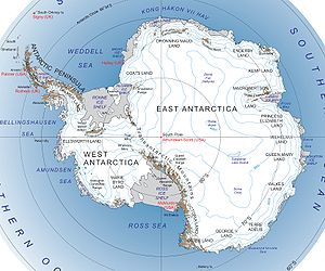
Queen Mary Land
DbpediaThing
Wikipedia articleDbpedia source
Queen Mary Land or the Queen Mary Coast (66°45′S 96°0′E) is that portion of the coast of the Australian Antarctic Territory lying between Cape Filchner, in 91° 54' E, and Cape Hordern, at 100° 30' E. It was discovered in February 1912 by the Australasian Antarctic Expedition (1911-14) under the leadership of Douglas Mawson, who named it for Mary of Teck, queen consort of George V.12px This article incorporates public domain material from the United States Geological Survey document "Queen Mary Land" (content from the Geographic Names Information System).
Tierra de la Reina Mary

Conceptual map: Tierra de la Reina Mary

Exclusive content for members of

D/i/d/a/c/t/a/l/i/a
Sign in

Mira un ejemplo de lo que te pierdes

Categories:

Tags:

Fecha publicación: 18.9.2015

Comment

0

Do you want to comment? Sign up or Sign in

Join Didactalia

Browse among 224292 resources and 563494 people

Regístrate >

O conéctate a través de:

Si ya eres usuario, Inicia sesión

Do you want to access more educational content?

Sign in Join a class
x

Add to Didactalia Arrastra el botón a la barra de marcadores del navegador y comparte tus contenidos preferidos. Más info...

Game help
Juegos de anatomía
Selecciona nivel educativo