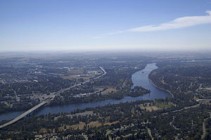
The American River (Río de los Americanos during the Mexican-ruled period before 1846) is a 119 mile long California river which runs from the Sierra Nevada mountain range to its confluence with the Sacramento River in the San Joaquin Valley. Via the Sacramento River, it is part of the San Francisco Bay and Pacific Ocean watershed. The river is fed by the melting snowpack of the Sierra Nevada and its many headwaters and tributaries, including the North, Middle, and South Forks. The river is known for the 1848 discovery of gold at Coloma which started the California Gold Rush and contributed to the initial large-scale settlement of California by European immigrants. Today, the river maintains high water quality and is the main source of drinking water for Sacramento. It is dammed extensively for irrigation, flood control and hydroelectricity generation. The American River watershed supports Mediterranean, temperate and montane ecosystems, and is home to a diverse array of fish and wildlife.
City
http://didactalia.net/items/Settlement_f1b3414b-55cf-49ef-8d26-e61dd24ff5f5_96820f2d-a820-4608-a5fc-6de9ad6b8540
Length (km)
191512.0
Maximum discharge (m³/s)
8891.49
Minimum discharge (m³/s)
6.08812
Mouth elevation (µ)
7.0104
Mouth position
http://didactalia.net/items/Book_14a9c2ed-aac2-4313-9216-830f2f3ac79a_40becd11-bd0a-47b0-9c5e-5d8596d78b14
Region
http://didactalia.net/items/Place_166bf637-91e1-492a-a591-17a5cafee280_b367f65a-1fe8-4ad9-9796-1e9457873012
Source confluence
http://didactalia.net/items/Lake_f07ea8cf-5854-49f1-a54d-ed91d95c0187_bc2222e8-4295-4eec-a0ac-662d49ed5bbf
Source confluence elevation (µ)
2255.82
Source confluence position
http://didactalia.net/items/Book_14a9c2ed-aac2-4313-9216-830f2f3ac79a_40becd11-bd0a-47b0-9c5e-5d8596d78b14
Source elevation (µ)
77.1144
2414.93
Source mountain
http://didactalia.net/items/Settlement_985d2de4-ebe1-4d9e-b595-402364e0f968_09f12991-f2b9-442a-b2db-49346c273466
Source place
http://didactalia.net/items/Settlement_985d2de4-ebe1-4d9e-b595-402364e0f968_09f12991-f2b9-442a-b2db-49346c273466
Source position
http://didactalia.net/items/Book_14a9c2ed-aac2-4313-9216-830f2f3ac79a_40becd11-bd0a-47b0-9c5e-5d8596d78b14
Source region
http://didactalia.net/items/AdministrativeRegion_f06d0626-84e7-4495-ac3b-df629002f0f1_34b72ce9-c68f-477e-a995-39a9561d7818
http://didactalia.net/items/Settlement_ee8126fe-9b99-4ecd-9c1a-a24e86d221a5_67e5f7d8-b5fe-4f44-8291-6364d0f05c80
State
http://didactalia.net/items/AdministrativeRegion_f7b3f31a-819c-4bdb-8f93-5ced5360fb0b_fb46551e-5637-4481-95af-ef4a2f9377b4
Watershed (km2)
5.56847e+09


Comment
0