What can I do?

226305 materialEducativo

textoFiltroFicha
  • I like 0
  • Visits 23
  • Comments 0
  • Save to
  • Actions

About this resource...

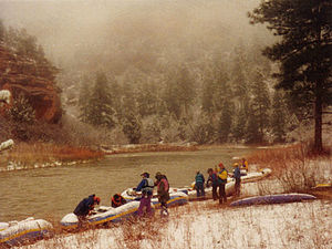
Chama River (Rio Grande)
River
Wikipedia articleDbpedia source
The Chama River, a major tributary river of the Rio Grande, is located in the U.S. states of Colorado and New Mexico. The river is about 130 miles (210 km) long altogether. From its source to El Vado Dam its length is about 50 miles (80 km), from El Vado Dam to Abiquiu Dam is about 51 miles (82 km), and from Abiquiu Dam to the mouth of the Rio Grande is about 34 miles (55 km).The name "Chama" is a shortened version of the Tewa term [tsąmą' ǫŋwįkeyi], meaning "wrestling pueblo-ruin".
Chama River (Rio Grande)
Length (km) 209214.720000
Maximum discharge (m³/s) 424.752699
Minimum discharge (m³/s) 0.033980
Mouth elevation (µ) 1712.976000
Source elevation (µ) 2840.736000
Watershed (km2) 8142922618.896384

Conceptual map: Chama River (Rio Grande)

Exclusive content for members of

D/i/d/a/c/t/a/l/i/a
Sign in

Mira un ejemplo de lo que te pierdes

Categories:

Fecha publicación: 22.9.2014

Comment

0

Do you want to comment? Sign up or Sign in

Join Didactalia

Browse among 226305 resources and 560604 people

Regístrate >

O conéctate a través de:

Si ya eres usuario, Inicia sesión

Do you want to access more educational content?

Sign in Join a class
x

Add to Didactalia Arrastra el botón a la barra de marcadores del navegador y comparte tus contenidos preferidos. Más info...

Game help
Juegos de anatomía
Selecciona nivel educativo