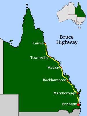
The Bruce Highway is a major highway in Queensland, Australia. Commencing in the state capital, Brisbane, it passes through areas close to the eastern coast to Cairns in Far North Queensland. The route is a part of the Australian National Highway and also part of Highway 1. Its length is approximately 1,700 kilometres (1,100 mi); it is entirely sealed with bitumen.The highway is named after the former Queensland and federal politician Henry Adam Bruce. He was the state Minister for Works when the highway was named after him, in the mid-1930s. It once passed through Brisbane, but was truncated at Bald Hills when the recently constructed Gateway Motorway became National Highway 1 upon its opening in December 1986.The Bruce Highway is the biggest traffic carrier in Queensland. The highway initially joined all the major coastal centres; however, a number of bypasses, particularly in the south, have diverted traffic around these cities to expedite traffic flow and ease urban congestion. As a result, the highway is constantly being shortened. The road is a dual carriageway from Brisbane to Cooroy with some dual carriageway lengths at Gympie, many of these upgrades being completed in the 1980s (Glass House Mountains, Tanawha, Maryborough) and 1990s (Nambour, Yandina, and Cooroy).In the south the Bruce Highway commences at the bridge over the Pine River at the Gateway Motorway interchange, 21 kilometres (13 mi) north of Brisbane central business district. Recently, the Bruce Highway has changed its route numbering from National Highway 1 to the M1 (motorway road) or A1 (single carriageway, generally with overtaking lanes).Several major cities along the route include Maryborough, Rockhampton, Mackay, Townsville, and Cairns. The highway passes the Glasshouse Mountains, rainforests and pastures in the Sunshine Coast, the Gunalda Range (north of Gympie), Mount Larcom (north of Gladstone), and the arid countryside north of Rockhampton; after that, it passes through land predominantly used for sugar cane, crop growing and dairy farms and the sub-tropics and tropics.
Is part of route
* A1 (Cooroy – )
* M1 ( – )
Length (km)
1652000.000000


Comment
0