
Cargando...
¿Qué puedo hacer?
Encuentra
 Matemáticas (278)
Ciencias Naturales (4699)
CC SS, Geografía e Historia (905)
Tecnología (205)
Artes Plásticas, Imagen y Diseño (177)
Artes Escénicas, Música y Danza (590)
Filosofía (262)
Lenguas Extranjeras (144)
Cultura y Lenguas Clásicas (26)
Matemáticas (278)
Ciencias Naturales (4699)
CC SS, Geografía e Historia (905)
Tecnología (205)
Artes Plásticas, Imagen y Diseño (177)
Artes Escénicas, Música y Danza (590)
Filosofía (262)
Lenguas Extranjeras (144)
Cultura y Lenguas Clásicas (26)
visualización
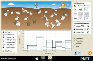
Hipervinculo Biología
Explore how organisms with different traits survive various selection agents within the environment.
Objetivos de Aprendizaje
Determine which mutations are favored by the selection agents of predator ...

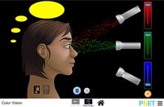
Hipervinculo Física
Make a whole rainbow by mixing red, green, and blue light. Change the wavelength of a monochromatic beam or filter white light. View the light as a solid beam, or see the individual photons. Objetivos ...
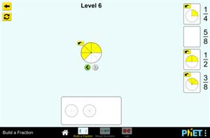
Hipervinculo Matemáticas
Build fractions from shapes and numbers to earn stars in this fractions game or explore in the Fractions Lab. Challenge yourself on any level you like. Try to collect lots of stars!
Objetivos de Aprend ...
Hipervinculo Física
Faça um arco-íris inteiro misturando luz vermelha, verde e azul. Altere o comprimento de onda de um feixe monocromático ou filtre a luz branca. Veja a luz como um feixe sól ...

This video shows how to orient yourself in the field in a traditional way through the use of a map and a compass, and through the use of map applications for mobile devices. Year of creation: 2019.

In this video GNSS technology foundations and use are explained, and also how it is used in mobile and in other more accurate applications, such as cartography or Earth dynamics knowledge. Year of cr ...

Although talking about earthquakes and tsunamis sounds exotic, they are very common and happen frequently near us. This video shows why they occur, the trigger and where the possibility of an event is ...

Video Economía
All the clues for understanding symbols, scale and relief of the National Topographic Map are in this video. Year of creation: 2019.

Discover the true shape of the Earth and how cartographic projections allow portray it in a flat surface in different ways depending on the purpose of the map. Year of creation: 2019.

A tour around the current technologies using satellites and airborne platforms for geographic information in order to study the territory and its changes. Year of creation: 2019.
Añadir a Didactalia Arrastra el botón a la barra de marcadores del navegador y comparte tus contenidos preferidos. Más info...


