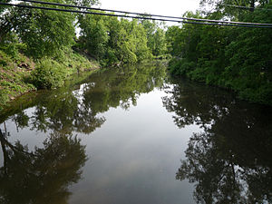
The Kinnickinnic River, called the Kinni for short, is a 41.4-mile-long (66.6 km) river in northwestern Wisconsin in the United States. It is listed as a Class I trout stream. The Kinnickinnic River rises from springs in St. Croix County and flows in a southwesterly direction before emptying into the St. Croix River in Kinnickinnic State Park. The city of River Falls, Wisconsin, named after a waterfall on the Kinnickinnic, is situated on the river. The name Kinnickinnic is a word from the Ojibwe giniginige, and refers to tobacco mixed with other plant material for smoking.The first settler along the Kinnickinnick River was Joel Foster. He spent his first winter in a walled-in cave overhang at Junction Falls near where the power plant now stands.The Kinnickinnic is composed of two types of river. Above River Falls, the river flows slowly, with a sandy/silty bottom and a narrower bed. Below River Falls, the bed is wider and is generally composed of stone rather than sand or silt. A substantial amount of silt and sand are deposited in the delta, enough that that section of the St. Croix is known as the "Kinnickinnic Narrows." The water is slightly colder above River Falls than below, as the dam in the city allows the water to sit and warm up before continuing.The differences in the stream make for differences in the fish population. The upper section of the river contains very high numbers of trout that are of smaller size. The warmer water below River Falls supports more minnow and crustacean life, which can support larger trout, though in fewer numbers. The extreme case of this is near the delta, where the water becomes even warmer, and the river supports warmer-water species such as smallmouth bass.The Kinni watershed is characterized by scenic bluff lands, rare oak savanna, original prairie, farm land, white pine forest, wooded coulees, sedge meadows, rare and endangered plant species, beautiful stands of white pines and plenty of open space and scenic vistas. Its feeder creeks are cold and clean, containing wild native brook trout, important spawning areas, wetlands, and many springs arising from under picturesque limestone outcroppings.Access is limited on this stretch. Public access on the lower river is mainly three spots downstream from the Glen Park dam and upstream form CYT Hwy F bridge at Kinnickinnic State Park two miles above the mouth.


Comentar
0