
Cargando...
Que pode fazer?
Encontrar
 Matemáticas (2689)
Ciências Naturais (8465)
Ciências Sociais, Geografia e História (3615)
Tecnologia (905)
Artes Visuais e Gráficas (813)
Artes Cênicas, Música e Dança (1443)
Filosofia (674)
Línguas Estrangeiras (2096)
Línguas e Culturas Clássicas (64)
Matemáticas (2689)
Ciências Naturais (8465)
Ciências Sociais, Geografia e História (3615)
Tecnologia (905)
Artes Visuais e Gráficas (813)
Artes Cênicas, Música e Dança (1443)
Filosofia (674)
Línguas Estrangeiras (2096)
Línguas e Culturas Clássicas (64)
Hipervinculo Matemáticas
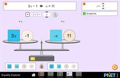
Explore o que significa para uma afirmação matemática ser equilibrada ou desequilibrada ao interagir com objetos em uma balança. Descubra as regras para mantê-lo equi ...
Hipervinculo Física
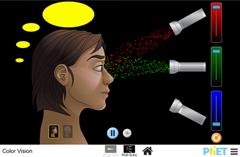
Faça um arco-íris inteiro misturando luz vermelha, verde e azul. Altere o comprimento de onda de um feixe monocromático ou filtre a luz branca. Veja a luz como um feixe sól ...
Hipervinculo Física
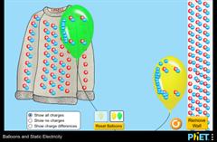
Pegue um balão para explorar conceitos de eletricidade estática, como transferência de carga, atração, repulsão e carga induzida.
Objetivos de aprendizado
Desc ...
Hipervinculo Matemáticas
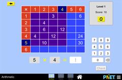
Lembre-se de sua tabuada? Pratique suas habilidades de multiplicação, divisão e fatoração com este jogo emocionante. Não são permitidas calculadoras!
Ob ...
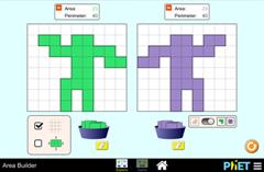
Hipervinculo Matemáticas
Crie suas próprias formas usando blocos coloridos e explore a relação entre perímetro e área. Compare a área e o perímetro de duas formas lado a lado. ...

This video shows how to orient yourself in the field in a traditional way through the use of a map and a compass, and through the use of map applications for mobile devices. Year of creation: 2019.

In this video GNSS technology foundations and use are explained, and also how it is used in mobile and in other more accurate applications, such as cartography or Earth dynamics knowledge. Year of cr ...

Although talking about earthquakes and tsunamis sounds exotic, they are very common and happen frequently near us. This video shows why they occur, the trigger and where the possibility of an event is ...

Video Economía
All the clues for understanding symbols, scale and relief of the National Topographic Map are in this video. Year of creation: 2019.

Discover the true shape of the Earth and how cartographic projections allow portray it in a flat surface in different ways depending on the purpose of the map. Year of creation: 2019.
Adicionar ao Didactalia Arrastra el botón a la barra de marcadores del navegador y comparte tus contenidos preferidos. Más info...


