
Cargando...
Que podo facer?
Atopa
visualización
Hipervinculo Geografía
Unidad interactiva en inglés con ejercicios sobre el concepto de escala, tipos de escala y la función de esta. 'Describing the different types of representation of the Earth and using the scale of th ...
Recurso interactivo en inglés sobre los mapas físicos y la lectura de estos. 'Describing the different types of representation of the Earth and learning about the difficulty of creating them.' Maps: ...
Hipervinculo Geografía
"Learning about the value of maps and the difficulty of creating them." Fuente: Proyecto Agrega
Geographic representation es un contenido didáctico publicado en Agrega (Red.es, Ministe ...
Hipervinculo Inglés-Lengua extranjera
"Teaching sequence that serves as an introduction to three-dimensional space: Maps, planes and models, among other topics " Fuente: Proyecto Agrega From planes to volume es un contenido did ...
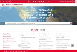
Enlazamos la versión en inglés de Mapas interactivos para aprender Geografía . Para las clases bilingües de esta materia: contiene mapas de España y el resto del mundo ...
Engadir a Didactalia Arrastra el botón a la barra de marcadores del navegador y comparte tus contenidos preferidos. Más info...


