
Cargando...
Zer egin dezaket?
Aurkitu
 Matematika (32)
Natur Zientziak (57)
Gizarte Zientziak, Geografia Eta Historia (275)
Teknologia (50)
Arte Plastikoak, Irudia Eta Diseinua (6)
Arte Eszenikoak, Musika Eta Dantza (5)
Filosofia (44)
Atzerriko Hizkuntzak (16)
Matematika (32)
Natur Zientziak (57)
Gizarte Zientziak, Geografia Eta Historia (275)
Teknologia (50)
Arte Plastikoak, Irudia Eta Diseinua (6)
Arte Eszenikoak, Musika Eta Dantza (5)
Filosofia (44)
Atzerriko Hizkuntzak (16)
ikustea

This video shows how to orient yourself in the field in a traditional way through the use of a map and a compass, and through the use of map applications for mobile devices. Year of creation: 2019.

In this video GNSS technology foundations and use are explained, and also how it is used in mobile and in other more accurate applications, such as cartography or Earth dynamics knowledge. Year of cr ...

Video Economía
All the clues for understanding symbols, scale and relief of the National Topographic Map are in this video. Year of creation: 2019.

Discover the true shape of the Earth and how cartographic projections allow portray it in a flat surface in different ways depending on the purpose of the map. Year of creation: 2019.

A tour around the current technologies using satellites and airborne platforms for geographic information in order to study the territory and its changes. Year of creation: 2019.

Bajo el lema “Descubre los tesoros de tu comarca”, este juego pretende concienciar sobre la importancia del desarrollo sostenible en el medio rural y poner en valor la cultura, la econom&i ...
Hipervinculo Economía
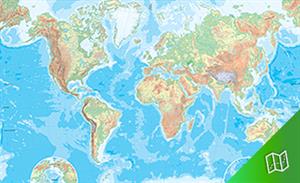
Representación cartográfica de los grandes elementos físicos del mundo: relieve, hidrografía continental y marina, litoral sin su toponimia. Proyección Van der Grint ...
Hipervinculo Economía
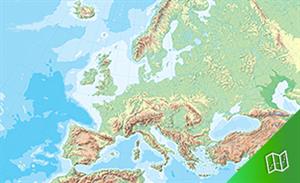
Representación cartográfica de los grandes elementos físicos del continente europeo y regiones limítrofes: relieve, hidrografía continental y marina, litoral sin su ...
Hipervinculo Economía
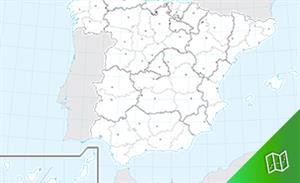
Representación cartográfica de la división política y las capitales de provincia y de Comunidad Autónoma de España. Datum ED50. Proyección cónic ...
Hipervinculo Economía
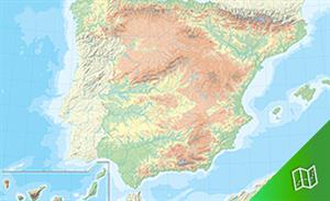
Representación cartográfica de los grandes elementos físicos de España: relieve, hidrografía continental y marina, litoral sin su toponimia. Datum ED50. Proyecci&oac ...
Didactalia-ri Gehitzea Arrastra el botón a la barra de marcadores del navegador y comparte tus contenidos preferidos. Más info...


