
Cargando...
What can I do?
Find
Display
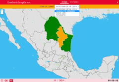
Do you know what is the name of each States of the region northeastern of Mexico shown on the map? Test yourself with this interactive map, you have to choose the right answer from a list of several o ...
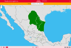
Would you know how to locate on the map the States of the region northeastern of Mexico which you have been asked for? You have to point out each exact location on the map.
Zoom in or zoom out the map ...
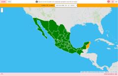
Do you know what is the name of each State of Mexico shown on the map? Test yourself with this interactive map, you have to choose the right answer from a list of several options.
Zoom in or zoom out t ...

Comprueba lo que sabes sobre geografía de México con este completo mapa interactivo en el que deberás señalar dónde se encuentran sus estados.
Los estados a localizar ...

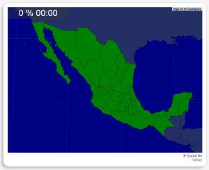
Would you know to locate the geographic items you are asked about? You must point out each exact location on the map.
Locate countries are: Aguascalientes, Baja California, Baja California Sur, Campech ...
Könntest du, die geographische Objekte ausfindig machen? Du musst auf die Landkarte genau zeigen, wo jeder sich befindet.
Die geographischen objekte, positionieren sollten, sind: Aguascalientes, Baja C ...

Ydych chi'n gwybod sut i leoli nodweddion daearyddol i gyd yn gywir? Gallwch chi ddangos hyn trwy gwblhau'r map rhyngweithiol gwreiddiol.
Gwledydd o hyd yw: Aguascalientes, Baja California, Baja Califo ...
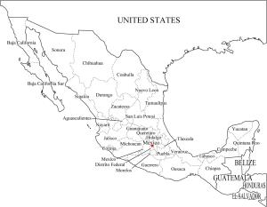
Si te cuesta memorizar los estados de México, te proponemos este mapa en el que aparecen señalados cada uno de ellos.
Es un mapa de Freemap creado por Sankakukei Inouekeisuke.
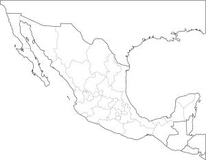
Con este mapa mudo de México puedes practicar tus conocimientos sobre los estados que forman este país.
Es un mapa de Freemap creado por Sankakukei Inouekeisuke.
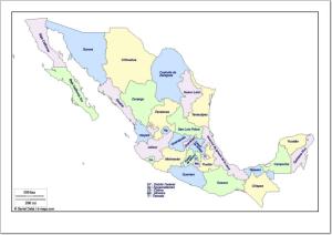
Mapa de México en el que se muestran los estados en los que se subdivide el país.
Es un mapa de d-maps creado por Daniel Dalet.
Add to Didactalia Arrastra el botón a la barra de marcadores del navegador y comparte tus contenidos preferidos. Más info...


