
Cargando...
What can I do?
Find
Hipervinculo Geografía
Contenido educativo en inglés para conocer los diferentes tipos de agricultura en Europa y Mediterráneo. 'Knowing what it consists of and its different types: extensive with high productivity, intensi ...
Hipervinculo Geografía
Unidad interactiva en inglés con ejercicios sobre el concepto de escala, tipos de escala y la función de esta. 'Describing the different types of representation of the Earth and using the scale of th ...
Recurso interactivo en inglés sobre los mapas físicos y la lectura de estos. 'Describing the different types of representation of the Earth and learning about the difficulty of creating them.' Maps: ...
Unidad didactica en inglés con actividades. El objeto de éste material es explicar las características cel clima oceánico y clima atlántico.'To learn about the characteristics of the oceanic climate a ...
Unidad didáctica (inglés) sobre las grandes llanuras que se ubican en el continente americano. El contenido ofrece material teórico y práctico con actividades.'To learn about the location of the major ...

Material educativo en inglés para trabajar la ubicación geográfica de las diferentes comunidades autónomas de España. En especial la actividad se centra en la Comunidad Autónoma de La Rioja.'Learning ...
Contenido educativo con actividades en inglés para conocer los principales lagos, golfos e islas del Continente Americano.'Learning about the continent's main lakes and islands.' Location of lakes, ...
Hipervinculo Geografía
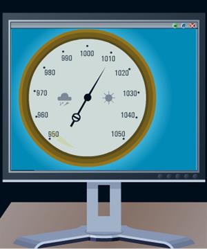
"Study of records and the graphic representation of weather" Fuente: Proyecto Agrega Initiation to records and precipitation es un contenido didáctico publicado en Agrega Red.es, el ...
Hipervinculo Geografía
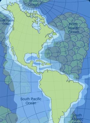
"Learning about the characteristics of the American river network and its distribution. " Fuente: Proyecto Agrega Hydrographic distribution of America es un contenido didáctico publ ...
Hipervinculo Geografía
"Learning about the value of maps and the difficulty of creating them." Fuente: Proyecto Agrega
Geographic representation es un contenido didáctico publicado en Agrega (Red.es, Ministe ...
Add to Didactalia Arrastra el botón a la barra de marcadores del navegador y comparte tus contenidos preferidos. Más info...


